
Ocean Currents: The River in the Sea
The Global Engine
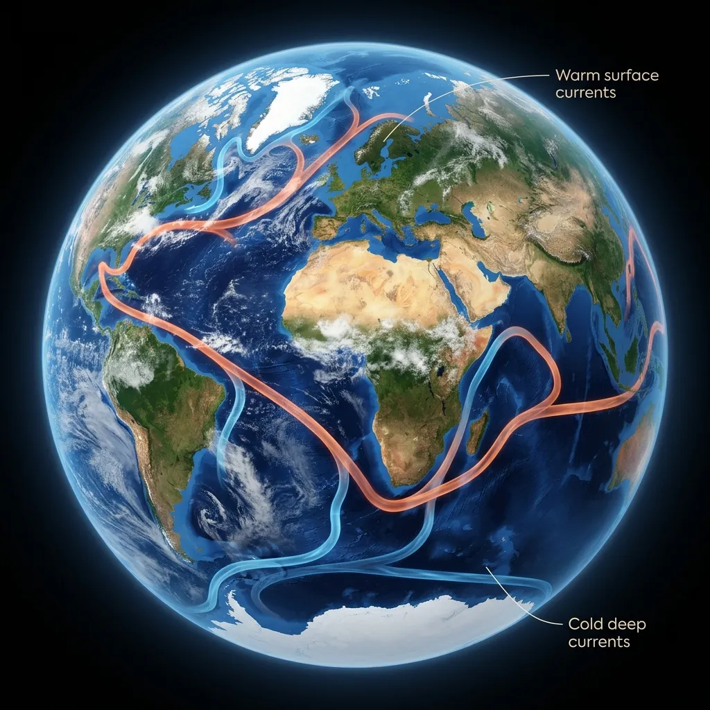
The ocean is not a bathtub. It is a moving engine. Giant rivers of water flow through the ocean, distinct from the water around them. These are Ocean Currents. The biggest one is the Gulf Stream. It is a monster river of warm water—faster and larger than the Amazon River—that rushes from the tropical Caribbean up to Northern Europe. It carries Heat. Without the Gulf Stream, England and Norway would be frozen solid like Siberia. It is a hot water heating pipe for the entire planet.
The Engine: Salt and Cold
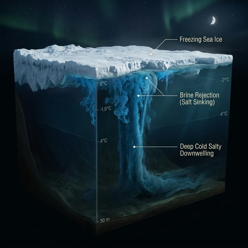
What pushes this massive river? Two things drive the ocean: Wind (Surface) and Density (Deep). The deep engine is called Thermohaline Circulation (Heat-Salt Circulation). It works like this:
- Warm water travels North to the Arctic.
- It gets cold and freezes into ice.
- Crucial Step: When saltwater freezes, the salt doesn't freeze. It gets dumped into the water below (Brine Rejection).
- The water below becomes freezing cold and incredibly salty.
- Cold + Salty = Heavy.
- This heavy water sinks like a stone to the bottom of the ocean.
- The sinking water pushes the water in front of it, starting a slow, deep current that crawls along the ocean floor all the way to Antarctica. It is called the "Global Conveyor Belt." It takes 1,000 years for a single drop of water to complete the loop.
The Rubber Duck Map
How do we map these invisible rivers? Sometimes, by accident. In 1992, a shipping container fell off a cargo ship in the Pacific. It burst open and spilled 29,000 plastic bath toys (Rubber Ducks, Frogs, and Turtles). It was a scientific goldmine. Oceanographers tracked where the ducks washed up. Some landed in Hawaii. Some in Alaska. Some froze in the Arctic ice, drifted over the North Pole, thawed out in the Atlantic, and washed up in Scotland 15 years later. Because of these "Friendly Floatees," we have the most accurate map of ocean currents ever made.
The Postmaster's Map
Who first mapped the Gulf Stream? Benjamin Franklin. Yes, the kite guy. In 1769, he was the Deputy Postmaster of the colonies. He noticed that mail ships from England took 2 weeks longer to get to America than American whaling ships took to get to England. Why? He asked his cousin (a whale captain), who told him: "The British captains are idiots. They are sailing against the current." Franklin measured the water temperature and drew the first map of the "Gulph Stream." He told the British Navy to avoid it to sail faster. They ignored him for 50 years.
The Garbage Patch
Currents move in giant circles called Gyres. The physics of a spinning pool means that anything floating on the surface gets pushed to the calm center. Trapped. Enter the Great Pacific Garbage Patch. It is a "plastic soup" twice the size of Texas floating between California and Hawaii. It isn't a solid island you can walk on; it is a slurry of confetti—billions of microplastics broken down by the sun. Fish eat the plastic. Tuna eat the fish. We eat the Tuna. The ocean is returning our trash to us on a dinner plate.
Finding Nemo was Real
In the movie Finding Nemo, the sea turtles ride the East Australian Current (EAC) like a super-highway. This is 100% real. Currents can move at 4-5 mph. That sounds slow for a car, but for a swimmer, it is a jet engine. Sea Turtles, Whales, and Tuna deliberately hop into these currents to migrate thousands of miles without swimming. It is free energy. Commercial shipping captains also use them to save millions of dollars in fuel.
The Stalling Engine
Scientists are worried. The Global Conveyor Belt is slowing down. As the ice caps melt, they dump fresh water into the North Atlantic. Fresh water doesn't have salt, so it isn't heavy. It doesn't sink. If the water stops sinking, the engine stops. If the current stops, Europe freezes, and the tropics burn. It would be a climate catastrophe unseen in human history. The engine has stalled before (during the Ice Ages), and we don't want it to happen again.
Fast Facts
- Upwelling: Sometimes wind pushes the warm top layer of water away. Cold water from the bottom rises up to replace it. This "Upwelling" carries tons of ancient nutrients (rot and dead stuff) from the deep. It is a buffet for plankton. Half the world's fish are caught in small "Upwelling Zones" because that's where the food is.
- El Niño: Every 3-7 years, the Pacific current mysteriously stops or reverses. The warm water sloshes back towards South America. This kills the fish (no upwelling) and ruins weather patterns globally. It causes floods in Peru and droughts in Australia.
- Submarine Hideout: Submarines use currents to hide. Different water temperatures reflect sonar differently. A sub can hide beneath a "Layer" of cold water (Thermocline) and become invisible to ships above.
Diagram Prompts
- Global Conveyor Belt: Map of the Earth. A giant ribbon of water winding through all oceans. Red ribbon (Warm surface water) going North. Blue ribbon (Cold deep water) going South. Label: "The Ocean Heat Engine."
- Thermohaline Pump: Cutaway view of the North Pole. Ice forming on top. Salt dropping down (Purple dots). Heavy water sinking down and pushing the current along the bottom. Label: "The Pump."
- Garbage Patch Gyre: Map of the Pacific Ocean. Arrows showing the circular current. In the dead center, a cloud of plastic debris trapped. Label: "The Vortex."